


Via the Zillertal high road to Hintertux and further on the Schlegeis Alpine Road

- Order number: 80279
Vorteile
- Kostenloser Versand ab € 35,- Bestellwert
- Internationaler Versand
- Erhältlich als DVD, Blu-Ray & Download
The first approximately 12.5 miles on mostly narrow and quiet side roads through the world renowned Zillertal to Kaltenbach (580 m), are ideal for a warming up for the challenges to come.
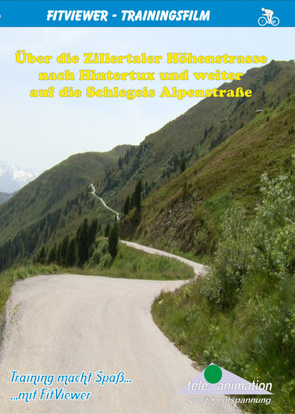
Here the very steep ascent up to the Zillertal-Höhenstraße tollgate begins - a distance of 5 miles. With average inclines of more than 11 %, it is the first demanding challenge.
The Zillertal-Höhenstraße is a panoramic mountain road in the alpine foothills of Tux, in the southern part of the Zillertal. At a height between 4813 and 6693 ft, a narrow, single-lane road meanders along the western hillside of the Zillertal. The whole length – including slip roads - from Kaltenbach to Hippach is approximately 24 miles
After the tollgate, the demanding ascent with inclines of between 12 % and 18 % continues for 2 miles to the Kaltenbach Ski hut at 5797 ft above sea level.
Past red blossoming alpine rose bushes, we enjoy a 984 ft long relaxing ride down into a dip until the junction for Hippach/Zellberg.
Pedalling hard again is the name of the game, before we reach the Mountain Pasture Hirschbichlalm at 6037 ft and afterwards Melchboden, the highest point at 6693 ft above sea level.
Now follows a beautiful and relaxing descent to Hippach (2034 ft) with beautiful views of the peaks of the Zillertal Alps and Hohe Tauern, with the 12008 ft high snow covered Großvenediger.
Now, the tour leads us for 10.5 miles via Mayrhofen (2133 ft), Finkenberg (2963 ft) and Lanersbach up to Hintertux, the world renowned winter sports resort in the Tux valley at 4921 ft above sea level. Afterwards we ride back to Finkenberg.
Here, the road takes a turn towards the Schlegeis Alpenstraße, which begins in the village of Ginzling at 3281 ft above sea level. From here, there are approximately 9 miles to go via 8 bends and through 4 natural stone tunnels, before we reach the car park at the Schlegeis-Reservoir at 5906 ft above sea level, the destination of this very demanding tour.
Distance: ca. 118 km
Length: 269 Minutes
Available as:
The YouTube video was blocked due to your cookie settings.


